The Geography of Trinidad and Tobago
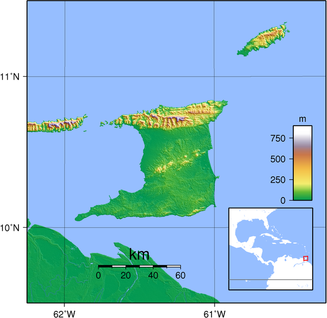
Trinidad and Tobago are located in the southeast corner of the Caribbean Sea, just north of Venezuela. The closest area of the United States (Florida) to Trinidad and Tobago is about 1,615 mi and a three hour flight. Trinidad is about 1,980 square miles, and Tobago is 115.8 square miles. Trinidad is the larger of the two islands, and Tobago is situated about 40 miles northeast of Trinidad. Visitors and citizens can take a ferry between the two islands that is about 3 hours long.

Trinidad has scattered topography. Trinidad has three main mountain ranges. The first is called the Northern mountain range and it consists of two large peaks: The first is El Cerro del Aripo and reaches 3,084 ft, and the second is El Tucuche which climbs to 3,070 ft. The second of the mountain ranges is called the Central mountain range and extends diagonally across the island, and reaches a maximum elevation of 1,066 ft. Finally, there is the Southern mountain range that consists of a broken line of hills that reaches a maximum elevation of about 1,000 ft.
Tobago is even more mountainous and is dominated by the Main mountain range which is 18 mi long and reaches a maximum elevation of 2,099 ft.
Tobago is even more mountainous and is dominated by the Main mountain range which is 18 mi long and reaches a maximum elevation of 2,099 ft.
Trinidad and Tobago consist of 365 km (or 226 mi) of coastline bordering the Atlantic Ocean, and Caribbean Sea, and consist of numerous bays, and beaches. The land between mountains is green and luscious, 43%f the land is forested, and the surrounding areas are flat plains. The land is rich with oil, and semi-fertile land.
Flora and Fauna are numerous in the islands. Compared to other Caribbean islands, Trinidad and Tobago have the most diverse species as, in the past, their land was attached to South America. Trinidad and Tobago's most famous flora an fauna include the nine-banded armadillo, the west Indian manatee, the little tobago (bird), and many interesting species of plants living in the tropical dry forests located on the islands.
Land use is a large subject in the islands, as space is limited. Space is used mainly for manufacturing plants, agriculture, retail and hotels, etc. This leaves an observer with the question, where do the islanders put their trash? Just like any other place, islanders throw away tons of trash each day (on average 4 lbs per day per person), so where does it all go on such a small island? There is an issue with where people put their trash, the people in the islands produce too much trash to have a place to put it, and conflict around this issue is a large topic. Currently, 1,000 tons of trash reach trash removal companies on the islands each day, and these companies along with the government are trying to find a way to make more space for it all. The method of land-filling is popularly used to remove this trash, and is done by filling the land with trash, and covering it up with dirt, and starting all over again with another layer, but space for this is limited. The largest of these landfills is called Beetham landfill, and it holds 65% of the islands' trash.
Trinidad and Tobago have beautiful land, but there are many issues surrounding how it should be used because it is so limited. Collectively, Trinidad and Tobago cover about as much as land as the state of Delaware, imagine trying to fit a whole country, and all that comes with it, into that small of a space. In comparison, Delaware can fit into the United States 1,528 times. Land use is an issue on many island nations, and it is interesting to see how each one handles its unique situation.
No comments:
Post a Comment